TECH TALK
How to Decipher Location Data Terms: ‘Precision’ vs. ‘Accuracy’
September 22, 2022

There is a lot to consider when evaluating mobile location data. Two terms that will come up in evaluation are “precision” and “horizontal accuracy.” Knowing what “precision” and “horizontal accuracy” mean in the location data world and their impact on data quality is vital to selecting the right data set for your organization’s needs.
Horizontal accuracy and precision can be confusing, as they sound similar. Let’s start with the definitions of each, specifically as they pertain to location data:
- Horizontal accuracy – the probability that the mobile location signal reported is within a circle of a given radius.
- Precision – the unit of measurement to which an area can be measured.
Precision can influence horizontal accuracy, but accuracy has much less of an influence on precision. To demonstrate this, let’s look at a simple example of how precision works.
Precision of Latitude and Longitude
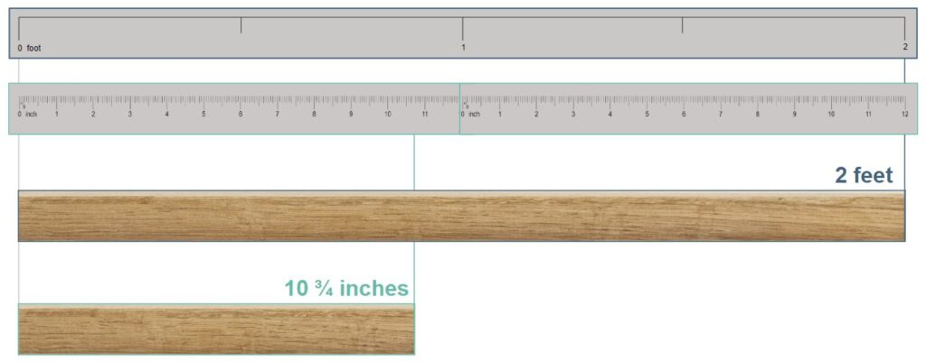
Imagine that we have a project where we need to cut lumber into pieces of specific sizes—one board at exactly 2 feet and one board at 10 ¾ inches. We have a tape that measures in feet. We also have a ruler that measures down to an ⅛th of an inch. We can use the tape to measure and cut the 2-foot board. Despite the larger scale, the tape measurer is precise enough to properly measure and cut the 2-foot board that we need. But to cut the 10 ¾-inch board, we would need the higher precision of the ruler to do the job. Using the tool with the wrong unit of measure, such as trying to cut the 10 ¾ board using the larger tape measurer, forces the operator to guess the measurement and reduces precision.
As it relates to mobile location data, the precision of the latitude and longitude coordinates associated with a location signal can negatively or positively affect the accuracy of the analysis conducted with that signal. Latitude/longitude coordinate precision is determined by decimal degrees. If you are interested in diving further into this topic, check out this table on Wikipedia that provides a detailed overview of the length of area that different degree decimals represent.
As an example, a latitude/longitude coordinate with a precision of 5 decimal degrees (typical for location signals from iOS devices) isolates activity down to the area of a building. A mobile location signal that provides a lat/long coordinate of 2 decimal degrees more loosely shows the activity of that device within the broader area of a town. The precision with which the signal’s location is reported by the device affects how accurately analysts can determine where the visit occurred on a map. Once the signal’s precision is established, then the horizontal accuracy can further impact how you interpret the data.
Horizontal Accuracy
When a mobile device reports its location, the precision of the location can be assessed by how many decimal degrees are apparent in each latitude/longitude coordinate. Sometimes, devices are also able to report a measure of horizontal accuracy associated with each location signal. This provides information on the likelihood that, based upon the precision of the location reported, the signal actually occurred within a defined area around that location versus outside of that area.
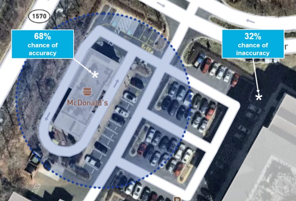
When Android reports a horizontal accuracy of 100 meters, they report it as a probability. Android states in its technical documentation on location that where a device returns an estimated horizontal accuracy radius in meters of a location at the 68th percentile confidence level, it means that there is a 68% chance that the true location of the device is within a determined distance of the reported location.
In the example above, there is a 68% chance that the visit indicated by a location signal falls within the circle drawn around this McDonald’s. That means that there is a 32% chance of the reported location being anywhere outside of the defined circle, and the visit could have actually occurred in front of the office building next door. The reported location is likely to be closer to the circle than halfway around the world unless there is fraud or an error in the calculation of the location.
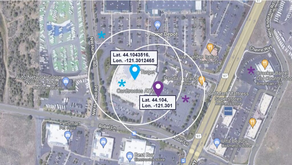
Now, let’s take into account the importance of starting with a precise location. Various decimal degrees of precision in the location signal can indicate different center points from which horizontal accuracy is determined.
In the example above, using the signal that has the most precise location coordinates, a decimal degree of 6, shows that the device was observed inside the Target store. The less precise location signal, with a decimal degree of only 3, places the mobile device just out front of the store at that time. If you layer in horizontal accuracy over the more precise latitude and longitude, it is still highly likely that the visit observed was inside the Target or just outside in the associated parking areas. When you look at horizontal accuracy over the less precise latitude and longitude coordinates, you start to see a different picture. The combination of lower precision offset with horizontal accuracy shows that it is probably more likely that the mobile device was observed in the shared parking lot in front of Target or at any of the other businesses nearby.
How Analysts Should Use “Precision” and “Horizontal Accuracy”
Although evaluating data for precision and accuracy is only one piece of the puzzle, it is necessary for determining the quality level and usefulness of the data for your specific needs. If those needs involve granular analysis of visits to an area, then a high level of precision is required. A quick review of the range of decimal degrees of the location coordinates in the data will give you an idea of whether the data set has the precision level needed. An aggregate-level analysis of activity in an area that includes signals with less precise location coordinates may still give you the right amount of data to work with.
Horizontal accuracy, although valuable, can be a less reliable method to use when you are evaluating data quality. The reason is that not every signal in a location data set has horizontal accuracy provided. Location data that includes horizontal accuracy is also valued at a premium by consumers of that data, which opens up an opportunity for estimation techniques and fraud.
Gravy Analytics has built a feature called Location Data Forensics into its data sets to enable analysts to more easily categorize and filter data. For more information on Gravy Location Data Forensics and how it can help your business, speak with a location intelligence expert from Gravy Analytics today.