GRAVY PRODUCT INSIGHTS SERIES
How Analysts & Researchers Use Gravy’s Location Data Forensics
September 26, 2023

What is Location Data Forensics?
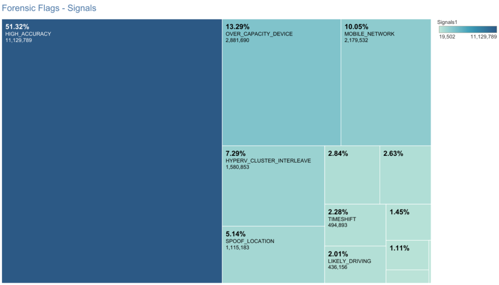
Location data forensics is a unique feature of Gravy’s Observations data, and it involves a process of separating high-quality location signals from low-quality, suspicious, and even fraudulent signals. By incorporating location data forensics into our data processing, we can ensure that you get the highest quality location data to support your research, analyses, and business decisions. These signals are then tagged with Gravy’s forensic flags that enable analysts to filter valid data by signal origin, location accuracy, and other key characteristics.
Problematic, suspicious, and fraudulent signals are some of the biggest differences between low-quality location data and high-quality location data. So, with Gravy’s forensic flags, you can exclude any data that isn’t useful from your analysis for an added level of customization and quality.
What Challenges Do Forensic Flags Solve?
Over 50% of location data signals are flawed in some way, but that doesn’t mean that this data can’t be used for analysis. In fact, there is a high level of value that can come from these flawed and flagged signals. With visibility into what makes those individual location signals flawed, analysts can determine which data points are right for their company’s needs.
For example, a signal that has been flagged as a potentially spoofed location would not be useful to include in a foot traffic analysis where high precision is paramount. That same data, however, would be highly valuable in fraud detection analysis, where consumer-provided location information needs to be corroborated against another dataset. So, while our location data forensics can help increase the accuracy and quality of your data, it can also add layers of potentially useful information to your analysis.

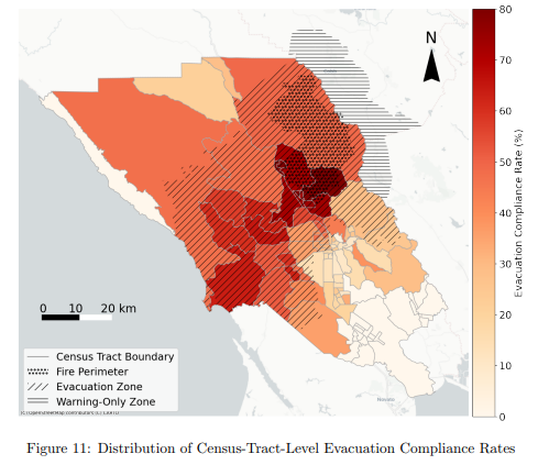
A Real-World Example: How the University of Florida Transportation Institute (UFTI) Used Forensic Flags
UFTI researchers currently use Gravy Observations data to study human mobility in evacuation zones around wildfire disasters, which can help inform emergency and disaster management policies. These researchers work with our data because of its transparency and flexibility, allowing them to take advantage of our forensic flags for added context and insights.
In a recent study, UFTI researchers chose to exclude the Observations that were flagged as being reported from a “spoofed location” because those location signals would have skewed their data analysis. There was a different forensic flag that helped in the analysis, however. Gravy Observations flagged as “likely driving” were included, as those types of signals were equally effective in analyzing human mobility patterns in wildfire evacuation areas as those associated with pedestrian foot traffic. Read the full case study to learn more.
Top 4 Benefits of Location Data Forensics
By including a location data forensics feature in our Observations data, analysts can select the best location signals to work with for a variety of use cases. Additional benefits of this feature include:
- Transparent data with resulting insights you can trust
- Less time and fewer resources spent on preparing the data for analysis
- Potentially lower storage costs for smaller datasets
- Ability to use the same dataset easily for different types of analysis
For more information on which of Gravy’s location data forensic flags align with your analytics needs, speak with a location intelligence expert from Gravy Analytics today.