How Can Location Data Help Address the Issue of Food Deserts in the U.S.?
April 13, 2023

As society progresses, technology is playing an increasingly important role in addressing socioeconomic issues in the U.S. One such technology that has gained prominence in recent years is location data, which can provide invaluable insights for tackling these issues. But, how can this technology help to bring about real change in society?

Let’s use the issue of access to affordable and nutritional food as an example. Food deserts in the U.S. have been an issue for decades, developing as socioeconomic divides accelerate. An area is considered a food desert when a full-service grocery store or supermarket is more than a 10-minute walk away. Things like access to transportation, geography, and lack of incentive for grocery stores to expand into food deserts contribute to food deserts’ adverse effects on residents. Moreover, as Americans continue to grapple with post-pandemic economic disruptions like inflation, the demand for discount and dollar stores may be lowering demand for fresh food and full-service grocery stores in food deserts.
What Is a Food Desert?
Location data, and location intelligence solutions derived from it, can be used to help address issues like food deserts by helping to identify these areas and analyzing the behavior of residents living there. However, before delving into how these tools can help, it’s crucial to first understand what constitutes a food desert.
Food deserts have largely formed in areas with low populations and where residents have relatively little education and low incomes. Food deserts may be one reason why 51% of Americans have picked up unhealthy eating habits, and why 87% of Americans are worried about being able to afford groceries. Plus, food deserts look different in rural areas compared to urban areas. In rural food deserts, households can be more than 10 miles away from the nearest grocery store. Meanwhile, in urban food deserts, grocery stores are usually closer; however, transportation and economic issues still make accessibility to nutritious food a challenge. The bottom line is this: the presence of food deserts means that there are communities with little to no access to fresh, healthy food from grocery stores and supermarkets, and this leads to a variety of societal issues and health disparities.
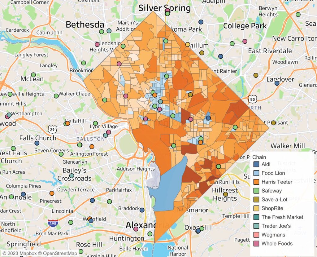
Using Location Intelligence to Analyze Food Deserts in Washington, D.C.
Through the use of location data, we at Gravy Analytics have gained valuable insights into the issue of food deserts in Washington, D.C., including consumer behavior in this area. After analyzing the data, we found that those who live in food desert areas have to travel longer distances to visit a supermarket. Furthermore, we found that although fast food restaurants are relatively accessible in all areas, those residing in food deserts are far more likely to visit fast food restaurants, consuming less fresh food than those living with easier access to grocery stores and supermarkets. Read our blog post that delves into all the key takeaways from our analysis, and explore our interactive dashboard to uncover more insights about food deserts in D.C.
Location Data & Food Deserts in the U.S.
Taking this idea further, how can location data aid in carrying out efforts to address the issue of food insecurity and food deserts? After using location data insights to better understand food deserts and consumer behavior in those areas, let’s talk about the ways in which these insights can be put to good use:
- Location-Based Mobile Apps: With the power of location data, mobile apps could soon begin to connect local fresh food growers to community organizations and small business owners in food deserts. This could lead to a wealth of opportunities to disperse fresh foods through newly formed networks of organizations and funding. NOURISH is a recent example of this type of technology. This is an application that uses artificial intelligence and geospatial data to build networks of key organizations in the community that can help increase access to fresh food in low-income food desert communities.
- Fresh Food on the Go: With accurate data of driving traffic and consumer foot traffic in food desert areas, organizations may be able to begin bringing fresh food into food deserts while on wheels. The Veggie Van in Niagara County, NY, is an example of what could come next on a larger scale. The Veggie Van works with local produce growers and brings fresh food to food desert neighborhoods each day at an affordable price. With this mobilization of fresh goods and the rapid growth of connected automobiles, location data may help expand efforts like these on a larger scale.
- Delivery Services for Accessibility: What about all the large grocery store chains and the delivery services they already use? Is it possible that location data could be used to identify neighboring food deserts to create a direct pipeline between full-service grocery stores and food deserts? From nationwide third-party delivery services to local initiatives and even new delivery services created specifically for the purpose of food desert relief, there is tremendous potential for leveraging delivery models to address the issue of low access to healthy food. For example, the mayor of Columbia, SC, recently pitched a plan to utilize delivery services for this purpose.
As technology continues to advance rapidly, these examples have the potential to be scaled up on a national level, offering much-needed relief to food-insecure households and providing healthier foods to those who have long been forced to rely on unhealthy options in food deserts in the U.S.
Food Deserts: A Societal Challenge
The issue of food deserts is more than just about nutrition options and access. Obstructed access to fresh, healthy, and nutritional food can have adverse affects not only physiologically, but psychologically as well. The inability to choose and purchase healthy food as a community can create an entire generation of heart disease, diabetes, and obesity. The rising costs of gas and food, combined with the prevalence of unhealthy eating habits in food desert populations, can lead to significant health and socioeconomic disparities that may also impact the mental well-being of these communities. Folks with health issues like obesity are more likely to struggle with mental health issues like depression. With the food insecurity that often comes with low access to nutritional food, the added stress may only make matters worse.
Overall, food deserts can have far-reaching effects that impact multiple aspects of peoples’ lives, as well as the health and well-being of entire communities and future generations. And what’s the key factor in determining which areas are most affected by this complex societal issue? It’s all about location. With location data at the forefront, it is encouraging to consider the various ways in which this technology can be harnessed to address the problem of food deserts. The development of new technologies in this space is particularly exciting, and holds great promise for making a positive impact on the lives of millions of people across the country.
For more on how location data can help address some of society’s biggest issues, learn about our Data for Social Good program, and subscribe to our email newsletter to learn more about Gravy’s location intelligence solutions.